
Floodwaters Raging
Local counties see high-water damage
Trending

The Inter-Mountain photo by Anthony Gaynor
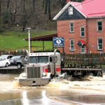
The Davis Street Park in Elkins was hit with rising water as flooding spread through Elkins Wednesday morning.
ELKINS -- Flooding caused traffic jams and property damage in Randolph and surrounding counties, as heavy rain continued to fall across the region Wednesday.
Randolph, Barbour and Tucker counties all saw substantial flooding and road closures. Elkins was one of the worst-hit areas hit as residents woke up to flooding Wednesday morning.
"We weren't expecting as much rain as we got in that short period of time," Elkins Mayor Jerry Marco said. "Nobody in the state has a system in place to handle that much water in that short period of time. I have been out and trying to help as much as possible today and it's a challenge right now. It came down quick and it came down hard."
Center Street, Weese Street and North Randolph Avenue in front of the Colonial Court service station were some of the flooded areas in Elkins.
"We have a lot of areas that are bad right now," Marco said Wednesday afternoon. "Elkins is kind of shaped like a bowl and water runs downhill and unfortunately we got hit hard today. People have water in parts of their yard where they've never had water before, and we had manholes with water bubbling up out of them -- it came down that hard. We are keeping people and the entire town in our prayers right now and hopefully the water recedes quickly."
Rob Daman, interim director of the Randolph County Office of Emergency Management and 911 Center, told The Inter-Mountain flooding issues had sprung up throughout Randolph.
"Water was pretty high all over the county," Daman said. "I was up in Valley Head and it was getting high up there early this morning. We have several roads impassable in the county, including Clifton-Nail Run, that runs right in front of the Leading Creek Fire Department, and 219 North was shut down from the Corridor H exit in Kerens all the way to the Tucker County line, due to flooding."
Road closures were also reported in Cravensdale next to the Little Arlington Cemetery, on Gum Road, downtown Coalton, and part of 219 next to Stalnaker Run.
In Barbour County, the Barbour County Commission declared a Local State of Preparedness for the county Wednesday afternoon as flood waters continued to rise. Many roads nearby rivers and streams had standing water, and several were impassable, including Teter Road, North River Road, Shooks Run Road, Vannoys Mill (Route 92 side), Salt Like Road (Route 92 side), Mt. Liberty Road, Union Road, Felton Hill Road and Arden Road.
The State of Preparedness allows the Barbour County Office of Emergency Management to utilize Emergency Operations Plans if necessary.
"We have several roads that are impassable and most of the creeks and streams in the county are out of their banks," Dylan Harper, the Barbour County OEM Deputy Director, told The Inter-Mountain on Wednesday. "It seems like in the county, Belington had the most amount of runoff overflowing in ditches and that kind of stuff. We are strongly urging citizens in the county not to try and cross any type of high water, turn around and don't drown."
Tucker County Office of Emergency Management Director Kevin White told The Inter-Mountain substantial flood water was causing issues in Tucker.
"We got a lot of water over here, not so much as in houses or anything, just roadways," White said. "We've had to close Route 219 to through traffic around the Moore Station Road, and Leading Creek is shut down at the intersection at Route 48. I don't know what sections for Parsons to Elkins are compromised, but there are some sections with water in the Montrose and Kerens area… I would recommend that drivers travel with caution and not cross any standing or pooled water roadways."
The National Weather Service in Charleston is calling for snow showers this morning and a mix of snow and rain between 1 p.m. and 3 p.m., with a high near 43 degrees. More snow showers mixed with rain are expected tonight before turning to all snow after 11 p.m.
The low overnight is expected to be around 33 degrees, with less than an inch of snow accumulating.